 |
| (Martin Waldseemüller’s map) |
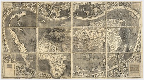
$10 million might be too much to pay for a map, but not if the map is nicknamed, “America’s baptismal document.” The map we are talking about is a four-and-a-half-foot-by-eight-foot map, the last surviving print of a map of the world made by the German cartographer, Martin Waldseemüller. The speciality of the map is that it is the first one to use the words, “America”, to mark the region known by that name today.
The name America itself comes from Amerigo Vespucci, a contemporary of Christopher Columbus, who was believed to have discovered the fourth continent in 1504. The word, believed is used here because the basis of Vespucci’s discovery was a document known as the Soderini Letter which was later found to be a forgery. Waldseemüller removed the name America from later maps and replaced it with “Terra Incognita”, but by then the name America had spread across other maps.
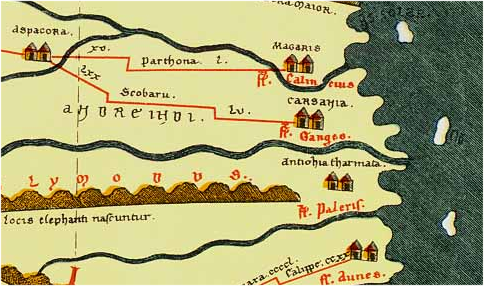 |
| (Tabula Peutingeriana showing the mouth of Ganges) |
Another rare map, about 200 years older than Waldseemüller‘s map was made public recently. This map called the Tabula Peutingeriana is the only map from the Roman empire showing the road from Spain to India. This copy made in the thirteenth century was based on a version last revised in the fifth century CE.
The entire map is available on this page and it looks odd because the length of the map is 6.75 m and the width is only 0.34 m. This segment in the map shows India and you can see Sri Lanka at the bottom mentioned as Insula Taprobane. The red lines in the map represent roads all of them really lead to Rome which is at the center of the map.
Every so often there is a little hook along the red lines which represents a rest stop – and the distance between hooks was one day’s travel.” “Every so often there is a pictogram of a building to show you that there was a hotel or a spa where you could stay,” he said.
“It was meant for the civil servants of the late Roman Empire, for couriers and travellers,” he added. Some of the buildings have large courtyards – a sign of more luxurious accommodation. [Ancient Roman road map unveiled]
Speaking of maps, another article in the NY Times says that the oldest map in the world comes from Jaora[1] near Bhopal, India.
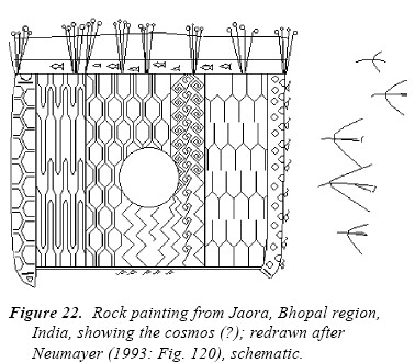
This may look like the drawing of a 48 month old when asked to depict some images from Finding Nemo (look for the fish at the top), but according to rock art experts, the image above drawn 7000 – 8000 years back represents the heaven and earth.
This painting shows a ‘square’ (actually a rectangle), divided into several stripes decorated with a variety of design patterns. An empty circle is in the centre. On the upper periphery of the square, ‘fish’ are shown between ‘reeds’ or ‘lotus stems’. Along two other sides are ‘water birds’, besides the rectangle are five ‘flying birds’. The geometric design within the rectangle does not seem to represent fields of agriculturists because this kind of design is also applied to animal bodies and is used independently. Neumayer assigns the rock art of this style to the Mesolithic period as only activities of hunters and gatherers are shown in contrast to pictures of other rock art styles [Berger ]
We have to see who will pay a million dollars for this rock art.
[1] Jaora Rock Art image from From Circle And Square To The Image Of The World by Friedrich Berger (Thanks Francesco)
I am thrilled to learn aboutthe map from jaora…,as I belong to Jaora.
Dr.Prashant Pathak